
The earliest known settlement in the area was an Indian village (Monasukapanough) located approximately five miles north of the present center of town on a hillside overlooking the Rivanna River. In the early 1700's settlers traveled the major east-west route from Richmond to a pass in the Blue Ridge mountains named Wood's Gap (Jarman's Gap), paralleling the James and Rivanna Rivers. This thoroughfare, the Three Notch'd Road or Three Chopt Road, threaded its way through the Southwest Mountains east of the current town at the Rivanna River Gap following an Indian hunting path through the region.1. As this route proceeded from the Rivanna River heading to the west, it followed a long ridge line separating two major drainage areas. Settlement along a dry ridge line was a common strategy for early Virginia villages, although unlike Charlottesville with its inland location, most of the early plantations and villages in the colonial period occurred with close proximity to the estuaries and rivers feeding the Tidewater region.
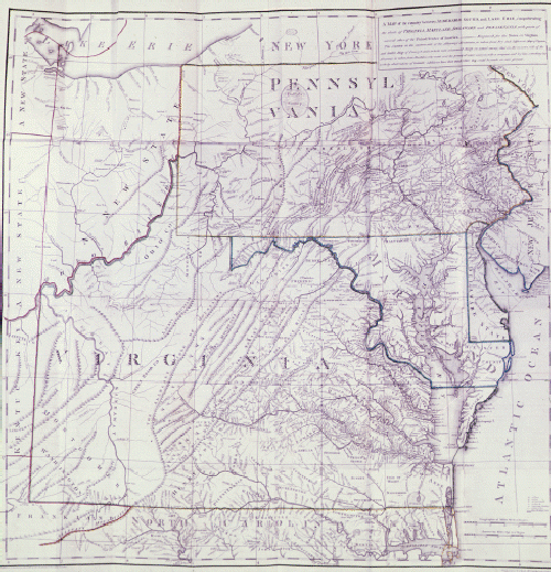
By the mid-1750's land grants were secured for a number of large parcels within Albemarle County. The first patents were recorded in 1727. In 1735 Abraham Lewis secured 800 acres in an area that currently includes the University of Virginia grounds, and Nicholas Meriwether secured 1,020 acres in the eastern portion of contemporary Charlottesville (in addition to a much larger tract of land to the east of the Southwest Mountains). In 1737, patents were issued to William Taylor between the Meriwether and Lewis tracks; this tract encompassed the area that would later become the village of Charlottesville.
All of these land grants were included within Albemarle County (named for the titular governor of Virginia from 1734-54, the Earl of Albemarle) when it was established in 1744. In its original formation, Albemarle was extremely large and its county seat was located "centrally" in the village of Scottsville (Scott's Landing) approximately twenty miles to the south of Charlottesville on the James River. Concerns arose over the size of the county and the difficulty in conducting the business of the county seat within such a large and increasingly settled area of the Virginia hinterland. In 1761 Albemarle was divided, considerably reducing its size down to 750 square miles and placing Scottsville along the extreme southern edge. The newly defined county purchased a 1,000 acre tract from Richard Randolph in a more central location, and in 1762 Charlottesville was founded by an Act of the Assembly as the Albemarle County seat.
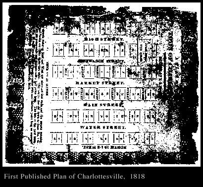
Charlottesville was established as a gridded town plan from the start. Dr. Thomas Walker was assigned by the County as Trustee, and a two acre public square was set aside for the courthouse at the northern edge of the fifty acre town. The site for the courthouse was selected on a hillside directly above the gridded village, several blocks above Three Notch'd Road or the main street of town. Over time, business activities around the Court Square included taverns, tailors, milliners, a printing shop, a gunsmith, and a jeweler. A portion of the original courthouse (1803) still stands as a part of the current complex of structures. The original twenty-eight block grid corresponds to the following existing streets: Sixth and McIntire on the east and west respectively, Jefferson and South on the north and south. A plan from 1818 indicated east/west streets as 66 feet in width, while north/south streets as 33 feet wide; this plan also indicated a two block by seven block annexation added directly to the north of the original grid.
In the early colonial period, Albemarle County included two Anglican parishes: St. Anne's and Fredericksville. Charlottesville however did not consecrate a church until 1824 (or 1826 according to Moore 2.). Following the construction of Christ Episcopal Church, a number of other denominations were founded within the city 3.(Lay, p.54): Presbyterian Church (1827), Baptist Church (1833), and Methodist Church (1834), all within the downtown grid. Until this point, church services were held within the courthouse itself. The absence of churches in the early town formation significantly affected the town's urban identity and growth. The sole point of civic focus was the courthouse and its enclosing square of shops and taverns, with an emerging mercantile area slowly appearing along Main Street several blocks below the courthouse.
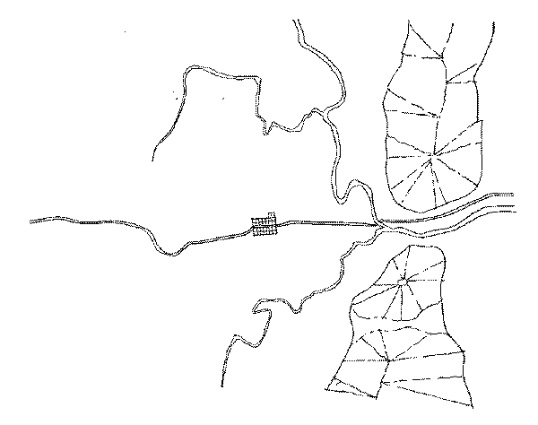
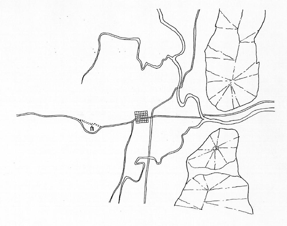
The geographic and topographic conditions of a town profoundly influence its subsequent development. At the regional scale, Charlottesville's separation from a navigable river complicated communication and trade, limiting its development before the arrival of railroads in the mid-nineteenth century. At the more detailed scale of the town's plan, Charlottesville's urban growth encountered and accommodated a series of influential factors including ridge lines, ravines, small hills, water sources, etc. The hilly terrain in particular led to the development of several independent and nearly disconnected neighborhoods within close proximity to the downtown area.
Throughout the early 1800's, business activity and urban development slowly began to shift from Court Square down to the Three Notch'd Road, now called Main Street. As James Alexander indicates in his Recollections from 1874, "Main Street as It Was in 1828 and as It Is at This Time. - This street, when we first knew it, had few houses, and only two or three business places on it, now it has from one end to the other, fine houses and substantial business stores; then it was rough, and in winter season with mud enough to stall wagons passing over it; now it is macadamized and is well graded; then there were only patches of paved sidewalks, now there are wide sidewalks laid with brick or slate its entire length."
Several distinct residential settlements emerged both within the original city grid and around its periphery. Park Street to the north and Ridge Street to the south included houses of prominent merchants and businessmen from the city. The westernmost section of downtown called Vinegar Hill and later Random Row, emerged as a business and residential center largely occupied by portions of the town's black population (see further discussion of Vinegar Hill under separate heading.) Other significant nineteenth century neighborhoods close to the downtown area or Main Street and included in this urban design study are Belmont, Star Hill, and Fifeville.
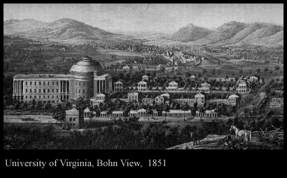
The University of Virginia was founded in 1819. As the institution's founder and principal visionary, Thomas Jefferson selected the site atop a small hill one mile from the center of town. The placement of the university away from the city established the "Academical Village" as distinct from the activities of town life. Jefferson's suspicions about the city and his clear preference for an agrarian basis of society in the newly formed republic are well documented, and it clearly influenced his attitude toward the founding of a non-sectarian and state supported institution of higher education. The University's location "outside of town" profoundly affected the subsequent urban development of Charlottesville by providing a strong westward focus of development, particularly along Three Notch'd Road (Main Street) connecting the University to the west and the town's center to the east. A small commercial area called The Corner developed adjacent to the University, supporting the student and faculty population as the institution grew.
In 1850 the Louisa Railroad Company, (later the Virginia Central and later yet the Chesapeake and Ohio) was the first to arrive in Charlottesville. In 1858 the railroad connected with the Shenandoah Valley through new tunnels in the Blue Ridge Mountains, thus facilitating a major expansion in the shipment of goods and raw materials through Charlottesville. The C&O station was situated toward the southern edge of the original town grid, below Main Street. In 1863 the Southern Railroad appeared, on a roughly north-south route, crossing the previous rail line midway between downtown and the University. This rail line led to a new station, later to be called Union Station, at the point of crossing between the north-south and east-west routes. The railroads, stations and freight yards sponsored new areas of development, particularly along the southern edge of the original grid, and paralleling Main Street between the University of downtown.3. The two crossing rail lines produced a new quadrant formation in the town's structure. The characteristics of each quadrant derive from the dominant activities and institutions; the University of Virginia in the southwest quadrant, downtown and its immediate neighborhoods in the northeast quadrant. The northwest quadrant remained largely undeveloped until the early part of the twentieth century, while the southeast quadrant emerged as the largest concentration of workers' housing. The junction of the two railroads between downtown and the University further invigorated that area (Star Hill) as it became a service center for the passengers and railroad workers who stayed at the hotels and ate at the restaurants. In addition, the railroad located a major repair shop in town which brought more industry and people to the region.
While the arrival of trains played and important role in the increased trade, manufacturing and communication in Charlottesville, the events of the Civil War left the urban fabric of the town almost completely untouched. Colonel Sheridan and Major-General Custer occupied Charlottesville on the way to Richmond in March, 1865. They remained for only three days, and aside from damage to they inflicted on the Woolen Mills, and the destruction of several bridges, they left the town unscathed. However, as with every southern town, many young men from the area died during the war. The two most notable activities in Charlottesville relating to the war were the manufacture of uniforms at the Woolen Mills and a desperately busy hospital for Confederate soldiers at the University of Virginia.
In 1854, the city held its first mayoral election. The mayor-city council form of town government continued until 1888, when Charlottesville was incorporated. At this time, a ring of land surrounding the original grid was annexed to create a city of 781 acres. This annexation and the slow recovery from the affects of the Civil War lead to a period of growth within the city. In 1887, the city received its first horse drawn street cars. An extra horse was kept at Vinegar Hill to assist cars in climbing the hill.
In 1895, the city macadamized the full length of Main Street, and the following year, East Market from Fifth to Eleventh Street also received the same improvement. "By 1920, the city had one mile of concrete paving, two miles of brick-surfaced streets, and eight miles of macadam. Since the city boasted it had forty-six miles of streets and alleys, this means less than one-fourth were paved in any manner whatsoever."4.
The turn of the twentieth century was a time of expansion and prosperity in Charlottesville. The increasing availability of good transportation in the form of rail and trolley lines, as well as graded and paved roads allowed easier travel to formerly distant parts of the city. Suburbanization began in these areas, especially near the University where housing was in high demand. Several farm holdings in the area were subdivided into suburban developments prior to World War II. Increasing development along the periphery of the town had the effect of slowly drawing activity away from the central business district. Areas such as Route 29 and Emmet Street on the north west side of town and Route 250 to the east became increasingly desirable locations for businesses and retail activity given the slow shift in population within the expanding city.
Charlottesville shared in the general post-World War II prosperity of the country as banks, business and transportation continued to expand. With the support of the GI Bill, the University experienced a rapid expansion as the areas largest employer. The physical growth of the campus occurred in the central grounds area and out toward the west and southwest, away from the downtown district. In addition to the effects of the University's growth, tourism began to play an increasingly important role in the area's economy. Before the war, the Thomas Jefferson Memorial Foundation purchased Monticello and along with the University of Virginia grounds, this proved to be a major tourist attraction for the area.
In the late 1950's and 1960's a bypass was constructed to divert traffic away from the downtown district. This allowed a smooth connection between the north-south route to Washington/Lynchburg with the east-west connector of Route 250 (paralleling the old Three Notch'd Road). In addition, a major east-west interstate was constructed (Route 64) passing a mile south of the town center.
These major highway improvements were a part of the national campaign to improve commerce and ease of travel in general. Another trend that Charlottesville experienced in the late 1950's and early 1960's also paralleled accepted doctrinaire planning practice of the time. Amidst controversy, and with a very thinly disguised racist agenda, the city decided to exercise "urban renewal" with the neighborhood of Vinegar Hill. This process of slum clearance occurred in tandem with a particularly tense and incendiary situation surrounding desegregation in general and school desegregation in particular. At the time, the exclusively white high school (Lane High) was located at the base of the Vinegar Hill neighborhood and the principal black school (Jefferson School) was located on the western edge. While the city was only temporarily successful in fighting the federal mandate for school integration, the impact of the city's treatment of the Vinegar Hill residents and urban fabric produced a profound and long lasting effect. As a part of this agenda, around five-hundred black residents of the city were displaced, and the primary commercial district for the town's African-American community was destroyed. In place of this active neighborhood, the city installed a major north-south connecting road (McIntyre) facilitating relatively high speed connections between Ridge Street and the Route 250 bypass. Eventually, a number of larger scale commercial buildings, a courthouse, apartments and condominiums and a hotel were constructed, situated typically amidst large areas of parking. In the mid-1970's, the city also decided to eliminate car traffic on Main Street downtown in favor of exclusive pedestrian access. The construction of the Mall was a part of this larger urban renewal strategy, attempting to staunch the flow of business activity away from the city center. Meanwhile, absent any significant zoning constraints within the county, the 1970's and 1980's witnessed extraordinary and virtually uncontrolled growth of strip developments in the peripheral areas of town.
Charlottesville Urban History:
Brief Notes
 Charlottesville Archive
 Return
to beginning
Return
to beginning
Make a suggestion.
 IATH WWW
Server
IATH WWW
Server